Wakatobi National Park

http://www.kompas.com/data/photo/2008/05/04/073905p.jpg
a very clear river in wangi-wangi island
image: Kompas


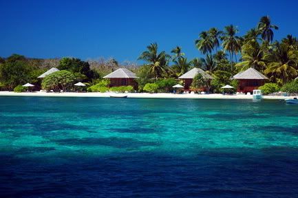
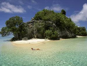
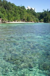
Wakatobi (an acronym for the main islands Wangi-Wangi, Kaledupa, Tomia and Binongko), is a renowned dive destination, featuring pristine and diverse reefs. The main islands have fringing coral reefs. It is located on South East Sulawesi, Indonesia. Wakatobi National Park has very high marine resource potential, in terms of both species and uniqueness, with enchanting submarine landscapes. In terms of configuration, the marine waters of the park generally start flat and then slope seawards, with sheer precipices in some parts. The water depth varies, the deepest parts reaching 1,044 metres with sand and coral at the bottom. This Park has 25 chains of coral reefs, and the total circumference of the coral islands is 600 km. The National Park includes an area of 1,390,000 hectares.

tr-wakatobi-underwater.jpg

Reefs:

- Karang Kapota situated ca. 20 km Southwest of Wangi-wangi (ca. 20 km long
and 8 km wide),
- Karang Keledupa situated ca. 20 km Southwest of Kaledupa and Tomia (ca. 60
km long and 20 km wide),
- the atoll-like reef situated just Southwest of Tomia Island that includes Lintoa
island (ca. 15 km long and 15 km wide).

A number of smaller reefs, mostly atolls, are situated in the open waters of the Southeastern part of Wakatobi. The Park is inhabited by ca. 85,000 people, whereof about half live in Wangi-Wangi. Many of these people depend on fisheries, but a significant portion also makes a living as inter-island traders and seafarers. Fishing is common throughout the Park, and there are frequent reports on destructive fishing practices being used. There are two main tourism hubs in the park namely, Tomia Island and Hoga in Kaledupa Island.

Wakatobi Aug12 (28) by pugletnelson.


The national park authority, PHKA, expressed a commitment to conserve these reefs by declaring the 1.39 million ha of waters around the islands as a protected area, Wakatobi National Park (TNKW, Taman Nasional Kepulauan Wakatobi) on July 30 1996 (Surat Keputusan Menteri Kehutanan No. 393 / Kpts-VI/1996). There is an endorsed zoning plan (Surat Keputusan Direktur Jenderal Perlindungan Hutan dan Pelestarian Alam No. 198/Kpts/DJ-VI/1997) that includes core zone, protection zone, use zone, traditional use zone, and rehabilitation zone. TNKW plans to revise the zoning plan to allow for socio-economic dynamics To date, Park management has not been effective because of problems faced by most Parks in Indonesia: lack of funding, lack of experience with marine conservation, and Indonesia’s social, economic and political crisis.

http://i368.photobucket.com/albums/oo123/kawaiine83/Wakatobi.jpg

Best visit :
April to June dan October to December.

How to get here:
From Jakarta you would transit in Kendari (Kendari is the capital of the Indonesian province of South East Sulawesi) afterwards it was continued to Bau-bau, will take up time around 5 hours if using speed boat or 12 hours if using traditional boat. From bau-bau to Lasalimu using car for two hours, then using the speed boat of Lasalimu-Wanci for one hour or the wood ship of Lasalimu-Wanci for 2.5 hours. Wanci was the first main gate entered the Wakatobi National Park region.

Bantimurung: Kingdom of Butterflies

One and a half century ago, Alfred Russel Wallace recorded as many as 250 species inhibited Bantimurung National Park in South Sulawesi. For that reason he named the area as butterflies kingdom. An updated research conducted by Prof Dr Sila Mappatoba, Msc, in 2005 showed that the species number of butterflies in the 43.750 ha park has declined to 125. Sadly, the latest data, in fact, mentioned that there are only 108 species left. Some of the species that can be found there are Graphium sarpedon, Idea blanchardi, Papilio memnon, Troides helena, Papilio blumei, and Caligo sp.


In Indonesian language, Bantimurung means "getting rid of sadness". Bantimurung is located on north of Makassar. The Bantimurung waterfalls are set amid lushly vegetated limestone cliffs. Bantimurung is crowded with Indonesians on weekends and holidays, and at other times it's a wonderful retreat from the congestion of Ujung Pandang (now Makassar), the capital of South Sulawesi. The best time to see living butterflies is when the sun appears after a rain shower.

But Bantimurung, it's not only about beautiful butterflies. Bantimurung is also famous with it's waterfall and caves. The waterfall is located at the valley of the steep limestone hill with its fertile tropical vegetation. Before entering the waterfall location, visitors can see a statue of a kind of monkey (lutung), about 6 cm tall. This kind of animal can only be found in Sulawesi and Kalimantan.

Bantimurung falls (Sulawesi (Celebes))

Bantimurung waterfall
image: Mongabay


The blue pool
image: Truly Indonesia


bantimurung caves

Bantimurung cave

Tomini Bay

Located in Gorontalo, North Sulawesi, Tomini Bay is famous for under water habitat and undefined creatures. There is several number of unsettled small islands. Tomini Bay is a heaven for divers, because the geographic position of Tomini Bay itself, which is crossed by the equator line, has naturally presented various kinds of sea creature inside.
pulau walea, tomini bay

The island is located in the Desa Olele or Olele Village is well known as the wild diving spot among world class diver. Olele beach is a gate to underwater paradise. The amazing beauty of underwater life on this area has been recognize and proofed by the enthusiasm of the divers who come to Olele beach. The divers called Olele as Traffic Jam dive spot.

tomini bay


In Tomini Bay and Olele Beach, you can find some or maybe the most amazing and diver creature such as:
* Lumba-Lumba hidung botol (torsiops trancatus)
* Giant Reef (Petrosia Sp.)
* Angkutan Kota (City Transport ” small car) also available
* School of Gobi Fish (Bryaninops erythrops)
* Salvador Dali reef (Petrosia lignose)
* Kipas Laut Biru (Acanthogorgia Sp.). There are only 3 acanthogorgia Sp. In Gorontalo
* Anemon Koralimorf (Discosoma Sp.)
* Nemo
* Ikan Behang (plectorhinchus chaetodonoides), some people call it cha-cha fish caused they dance and swim around the coral.
* Blenni (Escenius Caeruliventris)
* Cardinal Fish, damsel, platax pinnatus, scorpaenopsis, oxycephala, goropa fish, butterfly fish, pusillus, cockatoo fish, Randal fish, parapterois hetururus, Bothus Sp ” half face fish, frog fish, celebes
* Not forget to mention that Gorontalo is the Kingdom of Nudibrancia
* Seahorse and pigmy seahorse

There are just too many creatures to be named in Gorontalo, Just come, wear your suit and experience the Pieces of Paradise on the Equator.

.: source :.

Floating House on Danau Tempe


image: Truly Indonesia

Lake Tempe is located in Sengkang, South Sulawesi, Indonesia. Sengkang, the capital town of Wajo Regency is well-known as the center of Bugis silk industry, 240 kms to the northeast of Makassar. In Soppeng a spinning mill produces thread from silk worms. Weaving can be seen in many private homes along this route. The finest silk is handloomed by village women, each of whom can produce two metres of silk a month. Visitors are welcome to stop and watch, or make a purchase if there is any readily available.

Nearby Lake Tempe, is a tourist resort where you can enjoy boating.
In the middle of this lake, you can see hundreds of villagers floating houses

Every August 23rd, Festival Danau Tempe or Lake Tempe Festival is held. This fisherman's ritual feast called Maccera Tappareng or lake purify ceremony. It's started by cutting cattle, led by the head of the fishermen. On the day of the Festival Danau Tempe, all participants in the ceremony Maccera Tappareng dressed in Baju Bodo (traditional Buginese dress).

image: flaminggo dance

There are also various attractions, such as the traditional boat race, boat race tub, kites contest, the Anak Dara and Kalollo election (miss and mister Wajo), Mortar gong contest (padendang), traditional music and dance played by Bissu Waria, and many other.

Bukit Kasih Toar Lumimuut (Hills of Love)

Bukit Kasih Toar Lumimuut is a beautiful hill remains historical chronicle, situated in the vicinity or Kanonang Village, Minahasa Regency 55 km from Manado, North Sulawesi.

Bukit Kasih, which is surrounded by lush vegetation becomes a “Spiritual Sanctuary”, in which according to the legend of the Minahasan Tribe, is the place where the ancestors of Minahasan “Toar Lumimuut” died. Up on the hill, there are 5 worship places that represent the five religions such as: Mosque, Catholic Church, Protestan Church, Buddhist and Hindu Temples which can be reached by walking up the stairs. The monument of Life Together erected in thin tourism object illustrates the harmony among religious in North Sulawesi. Bukit Kasih is not merely a tourism object that is attractive to visit, but moreover it is a place of gathering for the people of North Sulawesi to pray and worship.


bukit-kasih-toar-lumimuut

http://sulawesi-maengkettours.com/Image/Monumen%20bukit%20kasih.jpg


How to Get There:

If you are in Manado, it easily reached by public bus from Manado’s Karambasan bus terminal heading for Kawangkoan then take a mikrolet or ponny trap “Bukit Kasih” or Hill of Love.


.: reference :.

Tana Toraja: Amazing Sceneries and Funeral Ceremony

The road from Makassar or Ujung Pandang to Tana Toraja (Toraja Land) runs along the coast for about 130 km's and then hits the mountains. After the entrance to Tana Toraja you enter a majestic landscape with giant gray, granites and stones and blue mountains at a distance after passing the market village of Mebali. They form a sharp contrast with the lively green of the fertile, rain-fed terraces and the rusty read of the tropical laterite soil. This is Tana Toraja, one of the most splendid areas in Indonesia.


gate of mebali, tana toraja
The Entrance Gate of Mebali

Tana Toraja has a specific and unique funeral ceremony which is called Rambu Solo. In Tana Toraja, dead body is not buried, but it is put in Tongkonan for several times, even can be more than ten years until the family have enough money to held the ceremony. After ceremony, the dead body is brought to the cave or to the wall of the mountain. The skulls show us that the dead body is not buried but just put on stone or ground, or put in the hole.The funeral festival season begins when the last rice has been harvested, usually in late June or July, and lasts through to September.

photo of the dead
The funeral ceremony sacrifice buffalos
a pig shapped coffin
Skulls outside a cave
One of Tana Toraja's cliff grave

How to Get There:


By Air
Directly from Sultan Hasanuddin International Airport, Makassar, proceed to Tana Toraja (twice a week on tuesday and friday) through the airport of Rantetayo, near Makle, 24 km south of Rantepao and there is a bus service to town.


By Land
Buses to Rantepao from Makassar leave daily from Makassar. The journey takes 8 hours and includes a meal stop. Tickets should be bought in town but coaches actually leave from Daya Bus Terminal, 20 minutes out of town by bemo. Coaches typically leave in the morning ( 7 am ), noon ( 1 pm ) and at night ( 7 pm).

Several companies in Rantepao run buses back to Makassar with the departure time and prices. The number of buses each day depends on the number of passengers.

Tourist who wants to stay in the heart of the city has many choices since there is lot of hotels and villas available. Or if you had an adventurous soul, you can sleep in villages on the way.

Bemo is the best way to get to know the locals, besides chartered vehicles (minibuses and Jeeps) with or without driver. While you are in the village you can take a walk to move around.

----------------

Things You Can't Miss:

  • Exploring the market; You should not to be missed going to the traditional market. Here you can get the top end of Toraja coffee beans [like Robusta and Arabica]. And several local veggies, fruits Tamarella or Terong Belanda and gold fish [ikan mas].
  • Visit Batu Tumonga Plateu; It means stone that facing to the sky. From here can be seen many volcanic stones comes up in between padi fields. And, several giant stones became cave graveyard. The views is pretty awesome. The huge of Tana Toraja [Toraja land] looks so lush and greenery. Like a patchwork in gradation hue of green color.

Ricefield Tana Toraja

  • Palawa is an excellent village to visit a Tongkonan, or a burial place still swarming with celebrations and festivals.
  • Take a side trip from Rantepao to Kete, a traditional village with excellent handicraft shops. Behind the village on a hillside is a grave site with lifesize statues guarding over old coffins called Tau-Tau.
  • Most of the times, you can't eat at these locations; however more warung and restaurants appear along the road. You can also bring your own foods and drinks.
  • There is some souvenirs shop where you can buy everything specific from Tana Toraja. There are clothes, bags, wallets and other handicrafts.
  • Visitor are expected to adhere to local dress customs and to bring a token present, such as cigarettes or coffee whenever entered Tongkonan.
  • As roads are not always paved, it is necessary to use a jeep or walk, even when the weather is good (between May and October).
  • Beware with your head whenever going inside to Tongkonan, The Torajan traditional house.
  • Enrekang, Makale and Toraja Higland are surrounded by astonishing volcanic rocky cliffs. Do not miss it , just stop and take picture for awhile and you will not regret.


.: referencee. with proper addition :.
.: pictures :.


Enter your email address:

Delivered by FeedBurner